Thanks to extensive research, the organisation of the commandery built in 1192 in Chamberaud is now better understood. Following the discovery of an aqueduct, numerous medieval pottery shards, the Napoleonic land registry and, above all, a medieval text describing the seigneurial estate in 1556, it is now possible to imagine what the village of Chamberaud looked like 500 years ago.
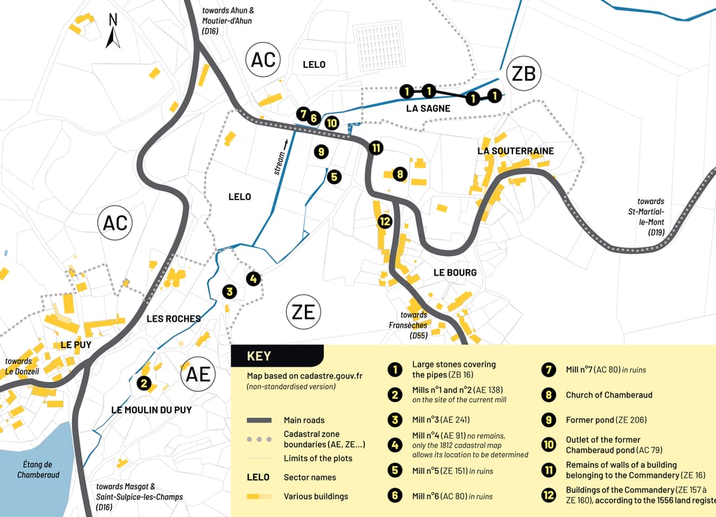
We have recently learned that there were seven mills in the commune of Chamberaud, all concentrated along a small stream. The stream is lined with stones on the sides in several places and sometimes even at the bottom. Its exact course has been completely traced thanks to its remains between ‘Les Roches’ and ‘La Souterraine’. Part of this canal is remarkable not only because it is well preserved, but also because it is covered by a dozen large stones. It fed a small pond near the village commonly known as the ‘old pond’, an area which is still marshy in the wet season.
Chamberaud
and archaeology
Countless shards have been found in and around the Commandery. What's more, the number of beautiful fragments is increasing, and we are beginning to get a clearer picture of the objects used nearly 700 years ago (according to experts' estimates). The pottery was wheel-thrown and made from a black clay with a high mica content. It was fired at a constant temperature (as evidenced by the uniform colour of the fractures). There are plates and vases of various sizes. Some fragments clearly show decorations, mostly in the form of braided cords. Only one metal object has been found: a run or drip that must have formed during the manufacture of another object. This leads us to believe that there was a forge not far from the current town hall.
Let us return to the organisation of the Commandery itself. Based on the remains at Chamberaud and the extract from the 1556 land register that has survived to this day, we have deduced the following layout: a wall surrounds the village of Chamberaud. It is a dry-stone wall, averaging 2 meters in height. Several parts of the wall remain to this day and its layout has therefore been largely recovered. The land register mentions this wall and indicates that inside it, facing north (“costé septentrion”), there were four “lodgings” in the same building. In the village of Chamberaud, there are four buildings lined up facing north that appear to be dilapidated. Furthermore, the structure of these buildings corresponds to their former functions as described in the land register (cellar, dwelling, stable, communal oven). These buildings are listed on the current land registry under the numbers: ZE 157, ZE 158, ZE 159, ZE 160. There was also another, second wall, which is mentioned in the description of the commandery, and we have managed to locate part of its route. It surrounded a dwelling, a stable, and a large round tower, and the south wall of the church formed part of this second enclosure wall.
Research on sites 1 to 11 was carried out in the spring of 1997 by Nicolas and Matthieu Peyne.
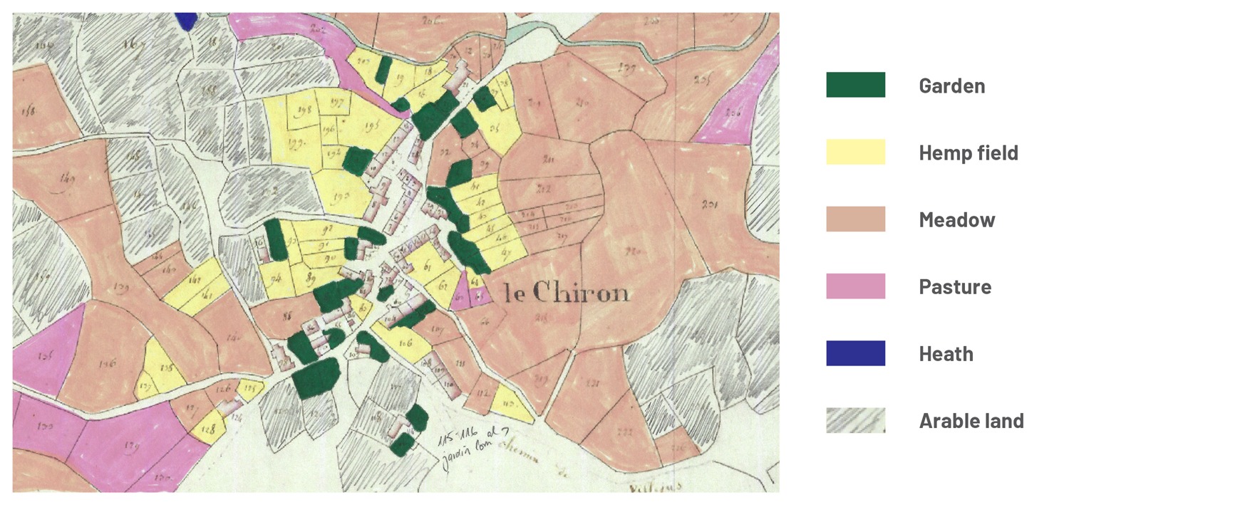
Use of plots at the beginning of the 19th century
An example from le Chiron
With descriptions of how each plot was used, we can get a clearer picture of what the villages looked like. The general layout was such that gardens were closest to the houses, with hemp fields forming a sort of second belt around the buildings and gardens. Beyond this area, which contained the most valuable and labour-intensive crops, were meadows, pastures and arable land.
The absence of forests or even copses is notable. Today, forests cover more than 30% of la Creuse. Until the 19th century, woods occupied only 3% of its surface area, with the rest being agricultural land and moorland.
Map retrieved from the Creuse Departmental Archives website (archives.creuse.fr)
and coloured in by Stephanie Dyson Heidrich
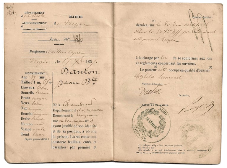
Portrait of a local mason : Jean-Baptiste Danton
He is a stonemason. Two workers' booklets give the following places of work from 1844 to 1861.
1844 and 1845: Auxerre (89) at P. Léger's contractor
1846: Etrepilly quarry (77)
1850: Lézinnes (89) with Léon Bennès, quarry man
1853: Bazelat (23)
1855: Troyes (10) with the Desmaret company
1856: Troyes (10) at the Parent et Schaken company for the construction
of the Paris-Mulhouse railway line1857: Périgueux (24)
At the end of 1860, he worked for six months on the construction
of la Chapelle du Puy in Bourganeuf.1861: Morlaix (29), on the town's viaduct construction site.
References/sources :
https://www.lesmaconsdelacreuse.fr/annuaires/general/danton-jean-baptiste and Philippe Buisson, family archives
1866 & 1872 census
Access the 12-page pdf file containing this information by clicking on the button below
All the data transcribed here has been taken from the Creuse Departmental Archives website: archives.creuse.fr
If you notice any errors in the transcription, please let us know by using the ‘CONTACT’ tab or by writing to us at: admin@chamberaud.com
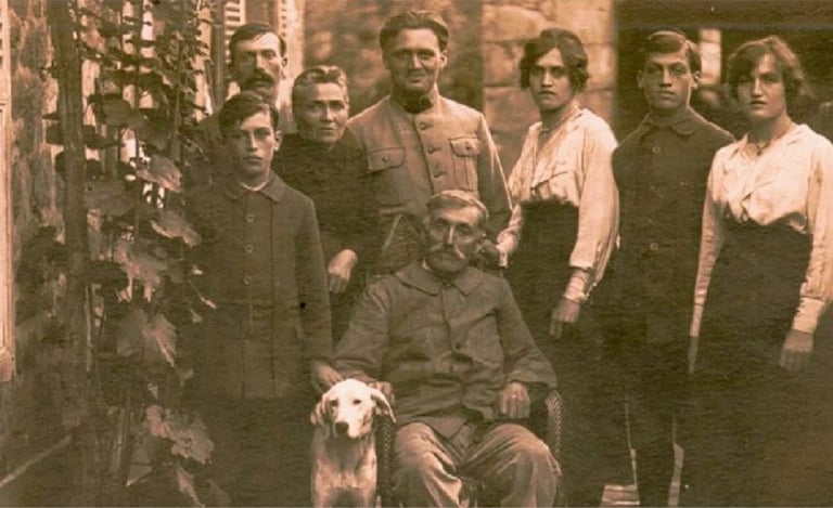
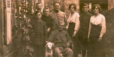
The Failly family at le Moulin du Puy
Chamberaud : a templar church
based on a monograph by Jean-Marie Allard
Chamberaud is a small rural commune in la Creuse (97 inhabitants according to the 2021 census), in the centre of the department between Guéret and Aubusson, near the ancient Roman road between Lyon and Saintes. It was a Templar commandery based on two orders: the Order of the Temple and later that of Saint John of Jerusalem.
The Orders of the Temple and the Hospital
The Order of the Temple, officially known as the Order of the Poor Knights of Christ, was founded in Jerusalem in 1120 by a knight from Champagne named Hugues de Payns. Its mission was originally exclusively military: to protect pilgrims, arms in hand. It was officially recognised by the papacy at the Council of Troyes in 1129. After 1291, with the fall of the last Latin strongholds in the Holy Land, the Order withdrew to Cyprus. King Philip IV of France, wishing to assert the authority of the royal state, had the Order suppressed by Pope Clement V on 3 April 1312. The masterfully executed round-up of the Templars in the Kingdom of France on the morning of 13 October 1307, the trial, and the burning at the stake of several of them helped to cement the Order’s place in the collective imagination, not to mention the numerous legends surrounding the supposed Templar treasure, which have fuelled a literature hungry for sensationalism.
The Hospitallers of Saint John of Jerusalem (also known as the Order of the Hospital) trace their origins to a hospital founded in Jerusalem by merchants from the Italian city of Amalfi around 1040, prior to the First Crusade. The aim was to provide shelter and assistance to pilgrims travelling to the tomb of Christ. It was, quite simply, an establishment often run by religious figures, which welcomed travellers by providing them with food and lodging, and sometimes medical care. After the capture of the Holy City by the Crusaders on 15 July 1099, the institution was transformed and recognised as a distinct religious order by a papal bull issued by Pope Paschal II on 15 February 1113. Whilst initially the order was purely charitable, it subsequently became a militarised order in the mid-12th century.
These two religious and military orders, tasked with protecting pilgrims travelling to the holy sites of Christianity and with defending the Holy Sepulchre and the Latin States of Palestine, revolutionised attitudes, as until then a clergyman had not borne arms. These orders constituted real permanent and disciplined armies, bound to defend their fortresses to the bitter end. In our region, both orders were present, under the authority of the Diocese of Limoges: 37 Templar houses and 33 Hospitaller houses. Thus Chamberaud joined the Order of Saint John of Jerusalem, remaining a member until the Revolution—more specifically, until the law of 19 September 1792, which abolished the Order in France; its properties, with the exception of churches and cemeteries, were sold as national assets.
The estates of both orders were, at least in our regions and in most cases, agricultural holdings. A portion of their income, known as the responsio, went towards the Order’s finances, namely the maintenance of fortresses and standing troops in the Holy Land and on the Iberian Peninsula. The typical layout of a commandery consisted of a church or chapel, more or less fortified dwellings, barns, stables, mills, forges and ovens.
The church and its stained-glass windows
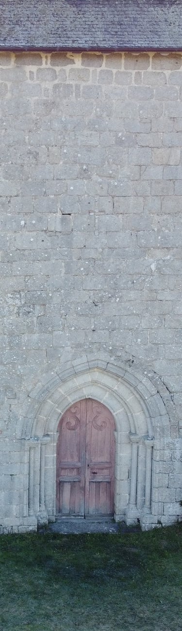
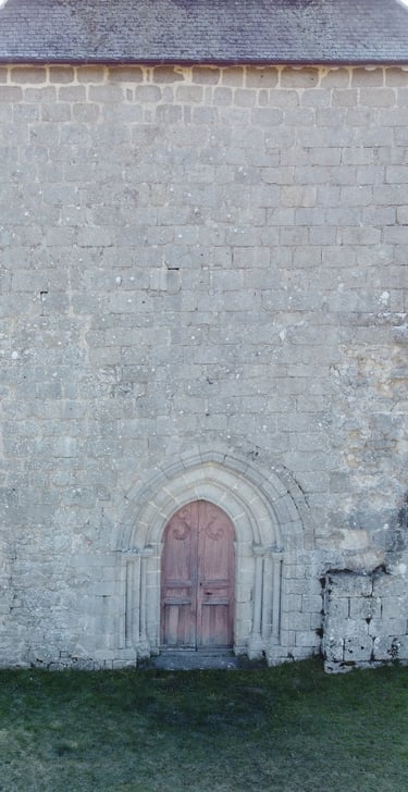
Perched on a bluff, at an altitude of around 500 m, the church was listed as a Historic Monument on 26 February 1991.
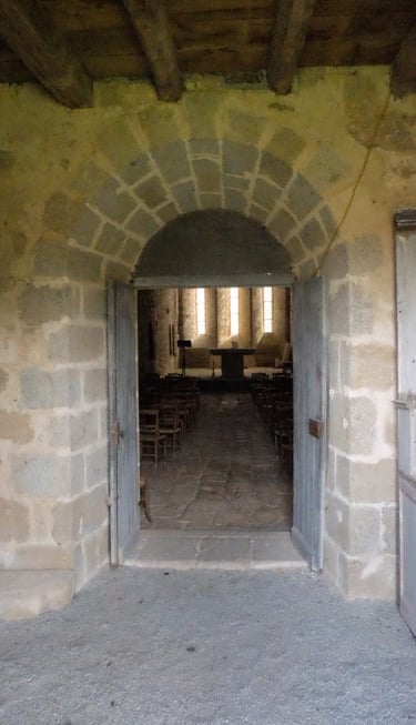
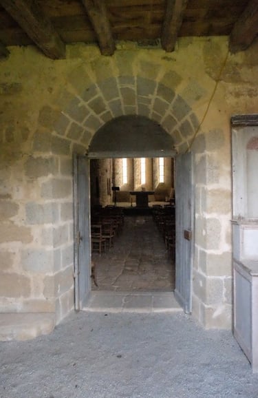
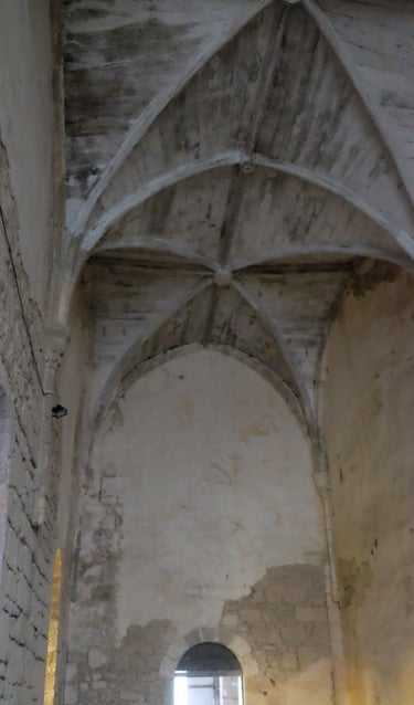
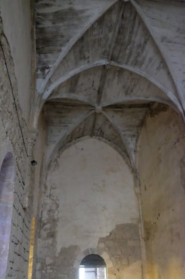
A rectangle measuring almost 30 m long and 8 m wide, it consists of a single-nave church with four bays; the flat chevet features three elongated windows; the bell tower – to the west – is in fact the former Saint-André tower (“a large square tower serving as a bell tower”, as noted in 1556). The building has undergone several alterations, making it the least uniform of the four Templar churches in La Creuse.
The original building must have been fairly low, but the chancel was subsequently opened up with a trio of windows, which allowed for the construction of stone vaults similar to those at Blaudeix and Charrières, other Templar churches in the department. It has two entrances, as specified in a land register from 1556; one provides access to the commandery, the other to the nave for parishioners, it is noted: clergy and laity each enter from their own side. This according to Auguste Bosvieux, archivist of la Creuse from 1852 to 1864, who travelled throughout the department in the 1860s and provided a description of the church. The three upper bays were rebuilt in 1775, “as indicated by a date placed above the central bay of the chevet”.
Inside, the nave is covered with ribbed vaults supported by wooden tie beams, imitating those that had collapsed: a keystone inserted into the south wall of the sacristy in 1858 bears witness to this. In 1879, an opening was made in the façade for the construction of the large doorway. The bell tower was repaired in 1819 and 1877 (the date is inscribed on a beam in the bell tower). The church lay abandoned for years and it was not until 1963 that restoration work began. In 1980, the bell tower, which had been struck by lightning in 1977, was repaired.
In his notebooks, Auguste Bosvieux gives the interior dimensions of the church (23.35 m long by 5.40 m wide), whose proportions he found “elegant”. In his view, some of the buttresses were “the most massive” he had ever seen.
The buildings and lands of the commandery
In the 1860s, A. Bosvieux notes that “the commandery building is situated in front of the façade, adjoining the church”. The cadastral map of 1812 shows a building adjoining the church to the west, forming an “L” shape as it extends northwards, with the cemetery to the south; nothing of it remains today. The commandery was meant to impress: in 1556, it is described as a “house situated on a hill with what appear to be moats in front, without water, consisting of a large courtyard surrounded by high walls […] There is also a round tower covered with flat tiles adjoining the church. By 1616, the castle was already partially destroyed. It then consisted of a large square tower adjoining a main building, a large courtyard, two other main buildings used ‘for the menagerie’ and ‘large hovels and ruins indicating that there had once been several buildings there”. Nearby are two barns and three mills. The commandery also had ponds and meadows, but above all a communal forge in the village of Chamberaud.
In 1890, in a study devoted to a family from Chamberaud, Father Parinet lamented the decline in the religious spirit of migrant stonemasons. Whilst noting that the ruins surrounding the church evoked memories of a Commandery of Malta, he highlighted the bad example set – in his view – by the Knights Hospitaller, which was being passed down from generation to generation. In the eyes of the Church, the rural inhabitants were turning away from God because the city was corrupting the emigrants, who brought back to the country bad new ideas and money. He adds: “The commanders, at least in the years preceding the Revolution, often abandoned their residences, leaving it to agents or farmers to collect the dues owed to them. These farmers, who were making a profit (these are Abbé Parinet’s words), sometimes resorted to extortion, or at least to somewhat harsh methods that outraged the peasants. To make matters worse, the Order’s properties, sold as national assets, were purchased by a sworn priest, who married and became the progenitor of a family that remained in the area until recent years.”
Jean-Marie Allard nous avait fait l'honneur de tenir une conférence en septembre 2023.
Il est l'auteur de l'ouvrage "Hospitaliers et Templiers dans la Creuse".
Minutes of the Chamberaud Municipal Council
between 1826 and 1902
All the data reproduced here was taken from the website of the Creuse Departmental Archives: archives.creuse.fr
Or how to understand the concerns of a municipality—some of which may endure, while others are specific to a particular era.
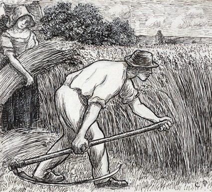
Camille Pissaro, around 1895